The Norwegian Coast Administration (NCA) are launching a digital route service

With this new digital route service, NCA are releasing 48 ready-made routes along the Oslofjord-coastline. The project will expand in the future to give navigators access to routes for the entire Norwegian coast. We at Telko are happy to inform our users that the shared routes are fully compatible with the latest version of TECDIS, 4.8.3.2, as they are based on the RTZ format.

Read more about the service here: Digital route service from the NCA

The NCA are inving all interested parties to a launch in Oslo on Monday 24th of September. The invitation is linked here.

TECDIS 2728 product picture

Introducing the TECDIS 2728

We are exited to announce that the all new TECDIS 2728 model is joining our TECDIS linup, with availability today!

TECDIS 2728 takes most of it’s cues from our long-running 2138A and 2138B line of standalone computers, and places that high end technology in the bezel of a gorgeous 27 inch display.

It is based on the Kaby Lake platform from Intel, and features a powerful Core i5 processor, 8 GB of blazingly fast RAM, 150 GB of storage on a removable SSD, and of course that gorgeous 27 inch Full HD display. The front of the unit is totally covered in glass, adding a premium look and feel to the bridge.

Software update: TECDIS 4.8.3.2 is released

Today, 21st of March, 2018, we are releasing a new update to the TECDIS software. This brings TECDIS to software version 4.8.3.2.

The most important feature of this update is the addition of import and export of routes in the RTZ format. RTZ is a standardized route exchange format, regulated by IEC 61174 Edition 4 from 2015.

We have also added several improvements and stability fixes to TECDIS with this release.


One improvement is the option to increase the display of target information. Course Over Ground (COG), Speed Over Ground (SOG), Closest Point of Approach (CPA) and Time to Closest Point of Approach (TCPA) can now be enlarged by simply clicking on any of the values.


You can download the update file here:  TECDISUpdate.exe
And we advise that you download and read the TECDIS Feature Guide for this release here: TECDIS Feature Guide 4.8.3.2.pdf
Unsure of how to add the update? Folllow this upgrade guide: TECDIS Update Procedure.pdf


Closer collaboration between Furuno Norway, Vico and Telko

Furuno Norway, Vico and Telko are uniting their forces to create new products and services in maritime electronics.

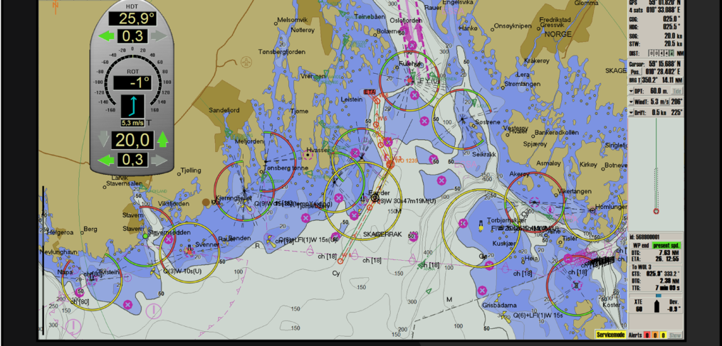
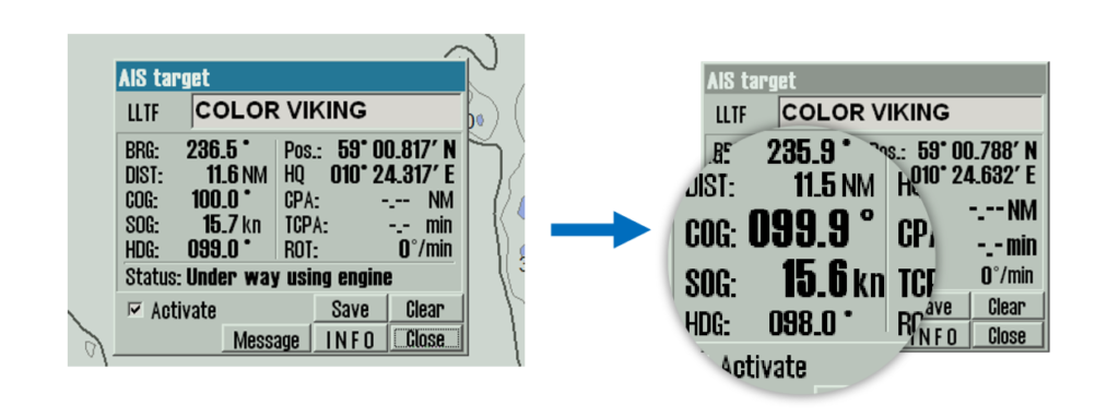
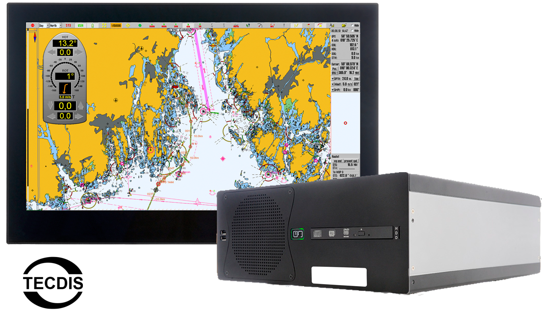
Telko AS has developed and manufactured the maritime navigation products TELchart and TECDIS for the last 20 years in close cooperation with Furuno Norway AS. Now the cooperation is strengthened, with a restructuring of Telko AS in preparation for a bright future.

In a private placement Furuno Norway AS and Vico AS are establishing a 25% share each of Telko AS. Telko Holding will remain as the largest owner with a 30% share, and IT Brekketoppen will have a 20% share. IT Brekketoppen is owned by Knut Vidar Lauritsen, the President of Telko AS since October 1st 2017.


Telko and Furuno Norway have renewed their exclusive distribution agreement for Telko products in the Norwegian market. Furuno Norway’s nationwide sales- and service network with Vico and 43 other dealers has been a vital part of the recipe for success for TECDIS and TELchart.

Internationally Telko will establish separate distribution channels.


The coming development of Telko will center around the established product lines, as well as expanding to e-navigation and digital services.

The three partners look forward to a close collaboration where great new navigation related solutions are created for our customers.


Contact information:

Knut Vidar Lauritsen
President, Telko AS
Email: knut.vidar@telko.no
Phone: (+47) 900 30 199


We are looking for Software Engineers

Here at Telko we are now actively looking for the right persons to join us on our journey towards the next generation of maritime navigation products.

We are starting this journey with an expansion of our R&D department, and if you are a software engineer, we hope you will read our job call and consider submitting an application.

You can find the job listing in our career section.


TELchart ECS 3.8.3.1 released!

September 15th, 2017:

Today we are happy to release the new generation of TELchart ECS software, 3.8.3.

You can download the update here: TELchart ECS Support


The update introduces the following changes to TELchart ECS:

  • Compliance with IHO S-52 Presentation Library Edition 4.0. [1724]
  • New Feature: Export of route report to PDF. [1733]
  • New Feature: ENC update status report, in compliance with IEC 61174 ed.4. [1738]
  • New Feature: Reset of settings to standard default values, and saving/loading operator settings now available via main toolbar ‘DEF’ button. [1769]
  • New Feature: Reception of sensor data via IEC 61162-450 sensor network. [1713]
  • New Feature: Single click chart loading for exchange sets generated by ChartCo PassageMaker 6. [1725]
  • New feature for moving LOP observations without pickup in chart. [1822]
  • New feature for addition of LOP bearing and range observations from radar cursor position. [1823]
  • Manual updates feature improved in compliance with IEC 61174 ed.4. [1748]
  • Area fill of mariner objects updated in compliance with IEC 61174 ed.4. [1750]
  • Cursor query of chart and cursor pick reports updated in compliance with IEC 61174 ed.4. [1751]
  • Chart legend updated in compliance with IEC 61174 ed.4, new feature for chart legend on cursor pick report location. [1754]
  • Handling of routes containing invalid turns improved and updated in compliance with IEC 61174 ed.4. [1756]
  • Lost AIS alert removed in compliance with IEC 61174 ed.4. [1757]
  • Handling of full target buffers improved and updated in compliance with IEC 61174 ed.4. [1760]
  • Anchor watch improved and updated in compliance with IEC 61174 ed.4. [1761]
  • Own ship and AIS target outline improved and updated in compliance with IEC 61174 ed.4. [1763]
  • Position source now shown in yellow when supplied by a non-contiguous position source, in compliance with IEC 61174 ed.4. [1764]
  • Alert system improved and updated in compliance with IEC 61174 ed.4. [1771]
  • Option for output of ALC, ALF, ARC and HBT to INS added in compliance with IEC 61174 ed.4. [1772]
  • Reception and display of sensor integrity data improved and updated in compliance with IEC 61174 ed.4, including support for NSR data from INS. [1773]
  • Navtex features improved and updated in compliance with IEC 61174 ed.4. [1774]
  • Range ring for automatic activation of AIS targets is now shown graphically, in compliance with IEC 61174 ed.4. [1775]
  • Chart viewing groups selection (‘More’ button in chart menu) improved and updated in compliance with IEC 61174 ed.4. [1776]
  • Chart menu improved and updated in compliance with IEC 61174 ed.4. [1777]
  • Chart loading improved and updated in compliance with IEC 61174 ed.4. [1778]
  • Chart library improved and updated in compliance with IEC 61174 ed.4. [1779]
  • Highlighting of safety contour crossing, navigational hazards and areas for which special conditions exists in accordance with IHO S-52 presentation library ed. 4.0 and IEC 61174 ed.4. [1728]
  • Improvements to cursor hover light information (active lights feature), including exanded cursor hover light information texts in accordance with IHO S-52 and improved handling of multi-color lights and multiple lights in one location. [1752]
  • Improvement to shown waypoint information in route reports (more of waypoint information text is now shown). [1726]
  • Improved system for chart notices (shown in top of chart display). [1727]
  • Improvements to VRM accuracy over large scales and ranges. [1753]
  • Improvement to user interface responsiveness during palette changes. [1805]
  • Improvements to replay mode. [1806]
  • Improvements to handling of routes generating a large number of route check dangers. [1818]
  • Additional zoom scale level 1:200 000 added. [1749]
  • Support and display for AIS SAR aircraft target added. [1766]
  • New option for disabling automatic activation of targes (‘off’ in active range in TGT menu), in compliance with IEC 61174 ed.4. [1759]
  • Chart notice ‘Relative vectors’ is now shown when target vectors are configured as relative. [1765]
  • Alert system caution added for lost connection to VDR. [1767]
  • Minor improvements to sensor configuration user interface in TELchart ECS Setup. [1781]
  • Minor improvement to dead reckoning accuracy. [1721]
  • Menu tabs are now automatically shown when cursor is moved to the lower right edge of the display. [1770]
  • Option for temporarily hiding main toolbar removed. [1755]
  • Support for old and new types of AIS meteo/weather data added. [1819]
  • Minor user interface change to own ship AIS configuration, making cargo setting unavailable for vessel types without the option for cargo information. [1758]
  • Full support for C-Map chart database ENC+. [1747]
  • Full support for C-Map database CAES added. [1804]
  • Added option for ECS MODE warning to be shown on special installations. [1809]
  • Added warning for uncalibrated brightness when monitor brightness is modified by external dimming solutions. [1820]
  • Chart engine fix for MS Visual C runtime error on cursor query of dredged areas in special circumstances. [1824]
  • Chart engine fix for ‘MS Visual C runtime error’ on route checks. [1814]
  • Fix for ignoring wind sensor data when wind direction is outside valid value range (0-360). [1803]
  • Fix for ignoring HDT and THS heading sensor messages without heading data. [1782]
  • Minor fix to parallel index line distance information mouse hover. [1732]
  • Fix for Navtex reception from Navtex units that don’t provide message reception date and time. [1813]
  • Fix for ‘g_mini->SetScale() failed’ message on startup. [1811]
  • Fix for transfer of routes with PI lines to other connected systems. [1817]
  • Fix for PI line issues on combined and reversed copied routes. [1816]
  • Fix for adding PI lines, ensured that PI lines can not be added by clicking on waypoint, only on route legs. [1825]
  • Fix for Datawash changing point symbols and PI line distance values. [1784]
  • Fix for issues with route danger review when radar overlay is active. [1821]
  • Fix for LOP distance observations being shown as solid circles in some special situations. [1815]
  • Fix for missing main toolbar menu button on 19 inch monitors with many features configured. [1807]


Software update: TECDIS 4.8.3.1

June 13th, 2017:

Today we released our first update to the new generation of TECDIS software, 4.8.3.

You can download the update here: TECDIS Support


The update, titled 4.8.3.1, introduces the following changes to TECDIS:

  • Improvements to handling of routes generating a large number of route check dangers. [1818]
  • New feature for moving LOP observations without pickup in chart. [1822]
  • New feature for addition of LOP bearing and range observations from radar cursor position. [1823]
  • Support for old and new types of AIS meteo/weather data added. [1819]
  • Added option for ECS MODE warning to be shown on special installations. [1809]
  • Added warning for uncalibrated brightness when monitor brightness is modified by external dimming solutions. [1820]
  • Minor GUI background color adjustment. [1808]
  • Chart engine fix for MS Visual C runtime error on cursor query of dredged areas in special circumstances. [1824]
  • Chart engine fix for ‘MS Visual C runtime error’ on route checks. [1814]
  • Multiple fixes and improvements to Harbour mode. [1810]
  • Fix for Navtex reception from Navtex units that don’t provide message reception date and time. [1813]
  • Fix for ‘g_mini->SetScale() failed’ message on startup. [1811]
  • Fix for transfer of routes with PI lines to other TECDIS. [1817]
  • Fix for PI line issues on combined and reversed copied routes. [1816]
  • Fix for adding PI lines, ensured that PI lines can not be added by clicking on waypoint, only on route legs. [1825]
  • Fix for Datawash changing point symbols and PI line distance values. [1784]
  • Fix for issues with route danger review when radar overlay is active. [1821]
  • Fix for LOP distance observations being shown as solid circles in some special situations. [1815]
  • Fix for missing main toolbar menu button on 19 inch monitors with many features configured. [1807]


 A full feature guide for this release should be expected by the end of the month.

TECDIS is now compatible with the new IHO Presentation Library 4 

With the release of the brand new TECDIS software 4.8.3, we have added the IHO Presentation Library 4.0, which is mandatory on all paperless TECDIS installations from August 31st and beyond.

The new upgrade to TECDIS brings with it massive changes to chart presentation, danger presentation, menus and some great new features.

Building on the stabile and solid 4.7.2.32-version, the new TECDIS 4.8.3 marks the shift to a new generation of TECDIS software. In the last 15 months TECDIS has been reinvented with several new functions, new color design and greatly improved alert and danger handling.

Read more about the features of TECDIS 4.8.3 in the Feature Guide.

We are ISO 9001:2008 re-certified

We are celebrating 5 years with ISO 9001:2008 certification, and are happy to announce that we have been re-certified for 5 new years according to the 9001:2008 standard. We will be adopting the new ISO 9001:2015 standard within this time frame, with a firm aim at 2017 for the final transition.

You can find more information on the Quality Assurance page.

Vessel detailsStep 1 of 5

TELCARE Order form

For subscription renewal codes.
Please enter the 7 digits of the IMO number